Posted by genlan Tuesday, September 29, 2009 0 comments


When work began on the Parthenon in 447 BC, the Athenian Empire was at the height of its power. Work on the temple continued until 432; the Parthenon, then, represents the tangible and visible efflorescence of Athenian imperial power, unencumbered by the depradations of the Peloponnesian War. Likewise, it symbolizes the power and influence of the Athenian politician, Perikles, who championed its construction.

Some historians believe that Athens concluded a peace treaty with Persia in 449, two years before work began on the Parthenon. The significance of this would be that the Delian League/Athenian Empire continued to exist, even after the reason for its existence (a mutual defense league against the Persians) had ceased to be valid. In other words it was now openly acknowledged that Athens was not just the head of the Greek defense league but actually an imperial master over other Greek states. The decision by the Athenians in 454 BC to move the League treasury from the Panhellenic sanctuary at Delos to the Athenian acropolis points in the same direction. Because the Parthenon was built with League funds, the building may be read as an expression of the confidence of the Athenians in this newly naked imperialism. But the piety of this undertaking should not be underestimated; the Persians had sacked the temples on the Athenian acropolis in 480, and rebuilding them fulfilled, in Bury's words, the Athenians' "debt of gratitude to heaven for the defeat of the Mede."

Setting | Architecture | Orders | Metopes | Pediments | Frieze | Ancient Authors | Other


Architectural Features

The Parthenon is a Doric peripteral temple, which means that it consists of a rectangular floor plan with a series of low steps on every side, and a colonnade (8 x 17) of Doric columns extending around the periphery of the entire structure. Each entrance has an additional six columns in front of it. The larger of the two interior rooms, the naos, housed the cult statue. The smaller room (the opisthodomos) was used as a treasury. Here is a plan of the temple:


Plan of Parthenon


It was built to replace two earlier temples of Athena on the Acropolis. One of these, of which almost no trace remains today, stood south of the Parthenon (between the Parthenon and the Erechtheum). The other, which was still being built at the time of the Persian sack in 480, was on the same spot as the Parthenon. We know the names of the architects (Iktinos and Kallikrates) and also of the sculptor (Pheidias) who made the massive chryselephantine cult statue of the goddess.

Setting | Architecture | Orders | Metopes | Pediments | Frieze | Ancient Authors | Other


The Orders

The three main types of columns used in Greek temples and other public buildings are Doric, Ionic, and Corinthian. The truest and most basic difference among the orders has to do with proportions (Doric columns, for example, being thicker and shorter, Ionic columns taller and slimmer). As a shortcut, the orders may be distinguished most easily by their capitals (the tops of the columns). As you can see from the following examples, the Doric capital has the simplest design; the Ionic has the curlicues called volutes, and the Corinthian has the acanthus leaves:

Doric Capital Ionic Capital Corinthian Capital

Doric is not only a type of column, but an "order"; this means that temples of the Doric order not only have this type of column, but also have a certain structure at the upper levels. The different types of orders (column plus entablature) are illustrated by these diagrams, from Perseus: Doric order, and Ionic order. The Doric order is characterized by the series of triglyphs and metopes on the entablature. Each metope was occupied by a panel of relief sculpture.

The Parthenon combines elements of the Doric and Ionic orders. Basically a Doric peripteral temple, it features a continuous sculpted frieze borrowed from the Ionic order, as well as four Ionic columns supporting the roof of the opisthodomos.

Setting | Architecture | Orders | Metopes | Pediments | Frieze | Ancient Authors | Other


The Metopes

The metopes of the Parthenon all represented various instances of the struggle between the forces of order and justice, on the one hand, and criminal chaos on the other. On the west side, the mythical battle against the Amazons (Amazonomachy); on the south, the battle between the Lapiths and the Centaurs (Centauromachy); on the east, the battle between the gods and the giants (Gigantomachy); on the north, the Greeks versus the Trojans. Of the panels the best preserved are those showing the Centauromachy. Here are South Metope 31 and 30 (compare the discussion in Pollitt, Art & Experience, 82-83):

For a complete catalogue, with images and descriptions of all the Parthenon metopes, see Perseus' Parthenon Metope Page (photos will be available only if you are on a Reed computer or a computer on another campus which has enhanced access to the Perseus photos by license agreement), and theAustralian National University collection (photos, but no text).

Setting | Architecture | Orders | Metopes | Pediments | Frieze | Ancient Authors | Other


The Pedimental Sculptures

These relief sculptures, larger than those of the metopes, occupied the triangular space above the triglyphs and metopes. Those at the west end of the temple depicted the contest between Poseidon and Athena for the right to be the patron deity of Athens (Athena's gift of the olive tree was preferred over Poseidon's spring). The eastern pedimental group showed the birth of Athena from Zeus' head. The pedimental sculpture suffered badly when the Parthenon was hit by a Venetian shell in 1687 and the powder magazine inside exploded. This reclining god (probably Dionysus) from the east pediment gives some sense of the quality of the sculpture:

For a complete catalogue, with images and descriptions of all the Parthenon pedimental sculpture, see Perseus' Parthenon East Pediment Page and West Pediment Page (photos will be available only if you are on a Reed computer or a computer on another campus which has enhanced access to the Perseus photos by license agreement).

Setting | Architecture | Orders | Metopes | Pediments | Frieze | Ancient Authors | Other


The Frieze

The Parthenon frieze runs around the upper edge of the temple wall. Its relatively small size (3 feet 5 inches tall) and placement (inside from the triglyphs and metopes) made it fairly hard to see from the ground. Unlike the metopes, the frieze has a single subject on all four sides. On three sides (north, west, and south) it depicts a procession of horsemen, musicians, sacrificial animals, and other figures with various ritual functions. On the east side there is a scene centered on a child handing a folded cloth to an older man. On one side of them seated gods and goddess are in attendance; on the other, two girls are carrying something. Although the state of preservation is poor, the interpretation of the subject has hotly debated. Most scholars agree that it represents the Panathenaic procession, but some think it is a mythical, "original" procession, while others believe that it is the procession which took place in the same period as the temple was built, and that this illustrates the (over-)confident spirit of the Athenians, who dared to put themselves where ordinarily only gods and heroes might be found.

Recently the debate has taken a new turn with the publication of a radical original theory by Joan B. Connelly. Here is a detailed summary of Connelly's ideas and some questions about them. Connelly's theory depends on a reinterpretation of this scene from the east frieze:

For a complete set of images and descriptions of the Parthenon frieze, see the Perseus Parthenon Frieze Page (photos will be available only if you are on a Reed computer or a computer on another campus which has enhanced access to the Perseus photos by license agreement).

Setting | Architecture | Orders | Metopes | Pediments | Frieze | Ancient Authors | Other


Ancient Authors on the Parthenon

Pausanias's Description of the Parthenon
Plutarch on Perikles' Troubles with the Parthenon Accounts


Other Views and Resources

Perseus' Main Parthenon Page
T.R. Martin's Chapter on the Periclean Building Program
T.R. Martin's Sub-section on the Parthenon
Plan, showing the layout of walls and columns, from Perseus
Reconstruction of the doors of the Parthenon, from Perseus
Perseus' Main Entry for the Ur-Parthenon
Minott Kerr's Lecture on the Parthenon


Posted by genlan 0 comments


The COLISEUM


The Coliseum (Coloseum, Colosseum), was built during the reign of Emperor Vespasiano c. 72 AD and dedicated in 80 AD by his son Titus. The popular name of Coliseum came about because the immense oval stadium was situated next to a colossal statue of Nero. The original name of this ancient Roman sports arena, the largest arena of its kind, is The Amphitheatrum Flavium.

Over 64 metres high with eighty entrances, the Coliseum could hold upwards of 50,000 spectators. Public events such as gladiator fights, mock naval battles and wild animal hunts were held at the Coliseum. During the staged fights as many as 10,000 people were killed. Fighters were slaves, prisoners or volunteers. Spectators saw persecuted Christians killed by lions. After 404 AD gladiatorial battles were no longer held, but animals such as lions, elephants, snakes and panthers continued to be massacred in the name of sport until the 6th century.

Mock naval battles were arranged by removing the heavy wooden flooring and flooding the lower cells, which usually housed the animals and prisoners. As gladiator fights proved to be more popular, the naval battles were ultimately moved to another site, and the wooden floors made permanent. During the middle ages, stones from the Coliseum were removed for new buildings.

Today, in Rome, the Coliseum is one of its most famous landmarks and tourist attractions. Although it survives only as a ruin, it still rates as one of the finest examples of Roman architecture and engineering.

Posted by genlan 0 comments


Pyramids of the Sun and Moon in Teotihuacan


Teotihuacan was, at its height in the first half of the 1st millennium CE, the largest pre-Columbian city in the Americas. The city during its existence was larger than any European city of the same era, possibly including Rome. The civilization and cultural complex associated with the site is also referred to as Teotihuacan. Its influence spread throughout Mesoamerica; evidence of Teotihuacano presence, if not outright political and economic control, can be seen at numerous sites in Veracruz and the Maya region. The city was located in what is now the San Juan Teotihuacán municipality in the State of México, Mexico, approximately 40 km (24.8 mi) northeast of Mexico City. It covers a total surface area of 83 kms and was made a UNESCO World Heritage Site in 1987.

The early history of Teotihuacan is quite mysterious, and the origin of its founders is debated. For many years, archaeologists believed it was built by the Toltec. This belief was based on colonial period texts such as the Florentine Codex which attributed the site to the Toltecs. However, the Nahuatl word "Toltec" generally means "craftsman of the highest level" and may not always refer to the archaeological Toltec civilization centered at Tula, Hidalgo. Since Toltec civilization flourished centuries after Teotihuacan, they cannot be understood as the city's founders.

In the Late Formative period, a number of urban centers arose in central Mexico. The most prominent of these appears to have been Cuicuilco, on the southern shore of Lake Texcoco. Scholars have speculated that the eruption of the Xitle volcano may have prompted a mass emigration out of the central valley and into the Teotihuacan valley. These settlers may have founded and/or accelerated the growth of Teotihuacan.

Other scholars have put forth the Totonac people as the founders of Teotihuacan, and the debate continues to this day. There is evidence that at least some of the people living in Teotihuacan came from areas influenced by the Teotihuacano civilization, including the Zapotec, Mixtec and Maya peoples. The culture and architecture of Teotihuacan was influenced by the Olmec people, who are considered to be the "mother civilization" of Mesoamerica. The earliest buildings at Teotihuacan date to about 200 BCE, and the largest pyramid, the Pyramid of the Sun, was completed by 100 CE.


The Pyramid of the Sun

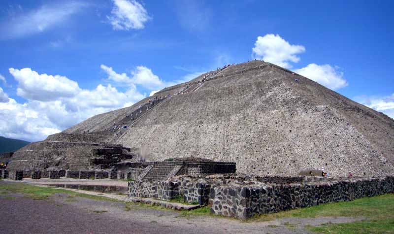
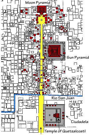
The Pyramid of the Sun is the largest building in Teotihuacán and one of the largest in Mesoamerica. Found along the Avenue of the Dead, in between the Pyramid of the Moon and the Ciudadela, and in the shadow of the massive mountain Cerro Gordo, the pyramid is part of a large complex in the heart of the city.

The name Pyramid of the Sun comes from the Aztecs, who visited the city of Teotihuacán centuries after it was abandoned; the name given to the pyramid by the Teotihuacanos is unknown. It was constructed in two phases. The first construction stage, around 100 A.D., brought the pyramid to nearly the size it is today. The second round of construction resulted in its completed size of 738 feet (225 meters) across and 246 feet (75 meters) high, making it the third largest pyramid in the world behind the Great Pyramid of Cholula and The Great Pyramid. The second phase also saw the construction of an altar atop of the pyramid, which has not survived into modern times. The Adosada platform was added to the pyramid in the early third century, at around the same time that the Ciudadela and Temple of the Feathered Serpent, Teotihuacan Pyramid of the Feathered Serpent were constructed.

Over the structure the ancient Teotihuacanos finished their pyramid with lime plaster imported from surrounding areas, on which they painted brilliantly colored murals. While the pyramid has endured for centuries, the paint and plaster have not and are no longer visible. Few images are thought to have been included in the mural decorations on the sides of the pyramid. Jaguar heads and paws, stars, and snake rattles are among the few images associated with the pyramids.

It is thought that the pyramid venerated a deity within Teotihuacan society but the destruction of the temple on top of the pyramid, by both deliberate and natural forces prior to the archaeological study of the site, has so far prevented identification of the pyramid with any particular deity. Some scholars have suggested that the deity of the pyramid was the Great Goddess, one of two major Teotihuacan deities and one of the few goddesses in ancient Mesoamerica. However, little evidence exists to support this theory.

Modern investigations

The first major archaeological excavation of the site was done by Leopoldo Batres in 1906. Batres supervised restoration of the Pyramid for the 1910 centennial of Mexican independence. Some aspects of Batres' reconstruction of the pyramid have been questioned by later archaeologists. Subsequent excavations of Teotihuacan have continued to the present. In 1925 Pedro Dosal discovered skeletons at the 4 corners of the foundations of the temple, which he interpreted as human sacrifices at the dedication of the temple.

Structure location and orientation

The orientation of the structure may hold some anthropological significance. The pyramid is oriented slightly northwest of the horizon point of the setting sun on two days a year, August 12 and April 29, which are about one divinatory calendar year apart for the Teotihuacanos. The day of August 12 is significant because it would have marked the date of the beginning of the present era and the initial day of the Maya long count calendar. In addition, many important astrological events can be viewed from the location of the pyramid that are important in terms of both agriculture and belief systems of the ancient society.

The pyramid was built over a man-made tunnel leading to a "cave" located six meters down beneath the center of the structure. Originally this was believed to be a naturally formed lava tube cave and interpreted as possibly the place of Chicomoztoc, the place of human origin according to Nahua legends. More recent excavations have suggested that the space is man-made instead, and could have served as a royal tomb. In 2008 scientists used muon detectors to try to find other chambers within the interior of the pyramid, but substantial looting has prevented the discovery of a function for the chambers in Teotihuacan society.

Recovered artifacts

Only a few caches of artifacts have been found in and around the pyramid. Obsidian arrowheads and human figurines have been discovered inside the pyramid and similar objects have been found at the nearby Pyramid of the Moon and Pyramid of the Feathered Serpent in the Ciudadela. These objects may have represented sacrificial victims. In addition, burial sites of children have been found in excavations at the corners of the pyramid. It is believed that these burials were part of a sacrificial ritual dedicating the building of the pyramid.


Temple of the Feathered Serpent

The "Temple of the Feathered Serpent" of Teotihuacan is an important religious and political[citation needed] center of the city. The Pyramid of the Feathered Serpent has revealed a great deal about religious ceremonies, burials, and politics in ancient Mesoamerica for the site of Teotihuacan. The structure contains some of the earliest-known representations of the Mesoamerican "plumed serpent" deity figure, most generally known by the term Quetzalcoatl, from the Nahuatl language of the much-later Aztec peoples.

The Feathered Serpent Pyramid is located at the Pre-Columbian site of Teotihuacán, which was at one time the largest city in the western hemisphere. The Feathered Serpent Pyramid is located in the Ciudadela at the South end of the Avenue of the Dead, a long avenue which is surrounded by platforms displaying the talud-tablero architectural style.

The Ciudadela

The Ciudadela is a Spanish term first used when the Spanish conquistadors arrived at Teotihuacán. It is a structure with high walls and a large courtyard that surrounds the Pyramid of the Feathered Serpent. The Ciudadela¹s courtyard is massive enough that it could house the entire adult population of Teotihuacán within its walls, which was estimated to be one hundred to two hundred thousand people during its peak. Within the Ciudadela there are several monumental structures, including the Pyramid of the Feathered Serpent, two mansions on the North and South side of the pyramid and the Adosada platform. The Adosada platform is located on the front, West side of the Pyramid of the Feathered Serpent, blocking its front view.

Architecture

The Feathered Serpent Pyramid is built in the talud-tablero style, with several platforms forming the pyramid. In between every platform there is a wall where a feathered serpent¹s head sticks outward. Its body wraps around the entire pyramid. Along with the feathered serpent there is also another figure that some believe is a representation of a crocodile or a representation of the deity Tlaloc. These figures alternate around the pyramid. In the eyes of these figures there is a spot for obsidian glass to be put in, so when the light hits, its eyes would glimmer. In between the heads a row of three shells can be found, showing that the people of Teotihuacán were trading with people along the Mexican coast. In antiquity the entire pyramid was painted. Today it is hidden by the adosada platform built in the 4th century hinting at political restructurisation of Teotihuacan during that time.

Burials at the Pyramid of the Feathered Serpent

The people of Teotihuacan believed in ritual sacrifice to satisfy the gods. Multiple burials were found at the pyramid, and it is believed that they were sacrificed as part of the dedication of the temple. The numbers of the burials are 4, 8, 9, 13, 18, and 20; these numbers represent significant ideology in Mesoamerica. There are four directions in the world, nine layers of their underworld, thirteen layers of heaven and earth, and a ritual calendar of thirteen months of twenty days or two hundred and sixty day calendar, and a solar calendar of eighteen months of twenty days.

Relation to the Calendar

As stated above there was a correlation between the Pyramid of the Feathered Serpent and a calendar for the people of Teotihuacán. The pyramid also is thought to contain two hundred and sixty feathered serpent heads between the platforms. Each of these feathered serpents also contains an open area in its mouth. This open area is big enough to put a place holder in. Thus, it is believed that the people of Teotihuacán would move this place marker around the pyramid to represent the ritual calendar. When a spiritual day would arrive the people would gather within the walls of the Ciudadela and celebrate the ritual.

Political influences

The Pyramid of the Feathered Serpent was not only a religious center but also a political center as well. The rulers of Teotihuacán were not only the leaders of men; they were also the spiritual leaders of the city. The two mansions near the pyramid are thought to have been occupied by powerful families. An interesting feature of the Feathered Serpent Pyramid is that there are examples of a shift in power or ideology in Teotihuacán and for the Pyramid itself. The construction of the Adosada platform came much later than the Feathered Serpent Pyramid. The Adosada platform is built directly in front of the pyramid and blocks its front view. Thus, it is thought that the political leaders lost favor or that the ideology of the Feathered Serpent Pyramid lost virtue and was covered up by the Adosada.


Teotihuacan reached its zenith between 150 and 450, when it was the center of a powerful culture whose influence extended through much of the Mesoamerican region. At its height the city covered over 30 kms (over 11 1/2 square miles), and probably housed a population of over 150,000 people, possibly as many as 250,000. Various districts in the city housed people from across the Teotihuacano region of influence that spread south as far as Guatemala. Notably absent from the city are fortifications and military structures.

The nature of political and cultural interactions between Teotihuacan and the centers of the Maya region (as well as elsewhere in Mesoamerica) has been a long-standing and significant area for debate in Mesoamerican scholarship. It is clearly established that substantial exchange and interaction occurred over the centuries from the Terminal Preclassic to the Mid Classic period, and that "Teotihuacan-inspired ideologies" and motifs persisted at Maya centers into the Late Classic long after Teotihuacan itself had declined.

However, there are several schools of thought contending the extent and degree of Teotihuacano influence, which range from a direct and even militaristic dominance, to one where the adoption of 'foreign' traits was part of a selective, conscious and bi-directional cultural diffusion. But because of new discoveries, it now seems that Teotihuacan was not much more different from the later empires, such as the Toltec and Aztec. It is believed that Teotihuacán had a major influence on the Preclassic and Classic Maya, most likely by conquering several Maya centers and regions including Tikal and the region of Peten, and influencing Maya culture.

Architectural styles prominent at Teotihuacan are also found widely dispersed at a number of distant Mesoamerican sites, which some researchers have interpreted as evidence for Teotihuacan's far-reaching interactions and political or militaristic dominance.

A style that has been particularly associated with Teotihuacan is known as talud-tablero, in which an inwards-sloping external side of a structure (talud) is surmounted by a rectangular panel (tablero). Variants of the generic style are found in a number of Maya region sites, including Tikal, Kaminaljuyu, Copan, Becan, and Oxkintok, and particularly in the Petén Basin and the central Guatemalan highlands.

However, it has been established that the talud-tablero style pre-dates its earliest appearance at Teotihuacan in the Early Classic period, and instead seems to have first originated in the Tlaxcala-Puebla region during the Preclassic.

Analyses have also been able to trace the development into local variants of the talud-tablero style at sites such as Tikal, where its use precedes the 5th-century appearance of iconographic motifs shared with Teotihuacan. Thus it appears that the talud-tablero style disseminated through Mesoamerica generally from the end of the Preclassic and not specifically or only via Teotihuacano influence. It is unclear how or from where the style spread into the Maya region.

The city was a center of industry, home to many potters, jewelers and craftsmen. Teotihuacan is known for producing a great number of obsidian artifacts. Unfortunately no ancient Teotihuacano non-ideographic texts are known to exist (or known to have existed), but mentions of the city in inscriptions from Maya cities show that Teotihuacan nobility travelled to and perhaps conquered local rulers as far away as Honduras. Maya inscriptions mention an individual nicknamed by scholars as "Spearthrower Owl", apparently ruler of Teotihuacan, who reigned for over 60 years and installed his relatives as rulers of Tikal and Uaxactun in Guatemala.

Most of what we infer about the culture at Teotihuacan comes from the murals that adorn the site (and others, like the Wagner Murals, found in private collections) and from hieroglyphic inscriptions made by the Maya describing their encounters with Teotihuacano conquerors. The creation of murals, perhaps tens of thousands of murals, reached its height between 450 and 650 CE. The painters' artistry was unrivalled in Mesoamerica and has been compared with that of Florence, Italy.

Teotihuacano culture

People

There is archaeological evidence that Teotihuacan was a multi-ethnic city, with distinct Zapotec, Mixtec, Maya and what seem to be Nahua quarters. The Totonacs have always maintained that they were the ones who built it, a story that was corroborated later by the Aztecs.

Language

In his 2001 paper,[17] Terrence Kaufman presents linguistic evidence suggesting that an important ethnic group in Teotihuacán was of Totonacan and/or Mixe-Zoquean linguistic affiliation. He uses this to explain general influences from Totonacan and Mixe-Zoquean languages in many other Mesoamerican languages many of which do not have any known history of contact with either of the above-mentioned groups.

Religion

The religion of Teotihuacan is similar to those of other Mesoamerican cultures. Many of the same gods were worshiped, including the Feathered Serpent and The Rain god. Teotihuacan was a major religious center, and the priests probably had a great deal of political power. As with other Mesoamerican cultures, Teotihuacanos practiced human sacrifice. Human bodies and animal sacrifices have been found during excavations of the pyramids at Teotihuacan; it is believed that when the buildings were expanded, sacrifices were made to dedicate the new building. The victims were probably enemy warriors captured in battle and then brought to the city to be ritually sacrificed so the city could prosper. Some were decapitated, some had their hearts removed, others were killed by being hit several times over the head and some were even buried alive. Animals that were considered sacred and represented mythical powers and military might were also buried alive but imprisoned in cages: cougars, a wolf, eagles, a falcon, an owl, and even venomous snakes.

Site Layout

The city's broad central avenue, called "Avenue of the Dead" (a translation from its Nahuatl name Miccoatli), is flanked by impressive ceremonial architecture, including the immense Pyramid of the Sun (second largest in the New World after the Great Pyramid of Cholula) and the Pyramid of the Moon. Along the Avenue of the Dead are many smaller talud-tablero platforms. The Aztecs believed they were tombs, inspiring the name of the avenue. Now they are known to be ceremonial platforms that were topped with temples. Further down the Avenue of the Dead is the area known as the Citadel, containing the ruined Temple of the Feathered Serpent. This area was a large plaza surrounded by temples that formed the religious and political center of the city. The name "Citadel" was given to it by the Spanish, who believed it was a fort. Most of the common people lived in large apartment buildings spread across the city. Many of the buildings contained workshops that produced pottery and other goods.

The geographical layout of Teotihuacan is a good example of the Mesoamerican tradition of planning cities, settlements and buildings as a representation of the Teotihuacano view of the Universe. Its urban grid is aligned to precisely 15.5º east of North. The Street of the Dead, in particular, seems to line up with Cerro Gordo to the north of the Pyramid of the Moon. Pecked-cross circles throughout the city and in the surrounding regions indicate how the grid was managed over long distances.

Archaeological site

Knowledge of the huge ruins of Teotihuacan was never lost. After the fall of the city, various squatters lived on the site. During Aztec times, the city was a place of pilgrimage and identified with the myth of Tollan, the place where the sun was created. Teotihuacán astonished the Spanish conquistadores during the post-conquest era. Today Teotihuacan is one of the most noted archaeological attractions in Mexico.

Excavations and investigations

Minor archaeological excavations were conducted in the 19th century, and in 1905 major projects of excavation and restoration began under archaeologist Leopoldo Batres. The Pyramid of the Sun was restored to celebrate the centennial of Mexican Independence in 1910. Excavations at the Ciudadela were carried out in the 1920s, supervised by Manuel Gamio; other sections of the site were excavated in the 1940s and 50s. The first site-wide project of restoration and excavation was carried out by INAH from 1960-65 and supervised by Jorge Acosta. This focused on clearing the Street of the Dead, consolidating the structures facing it, and excavating the Palace of Quetzalpapalotl.

During the installation of a 'sound and light' show in 1971, the entrance to a tunnel and cave system underneath the Pyramid of the Sun was accidentally discovered. Long thought to be a natural cave, more recent examinations have established the tunnel was entirely artificial. The interior of Pyramid of the Sun has never been fully excavated.

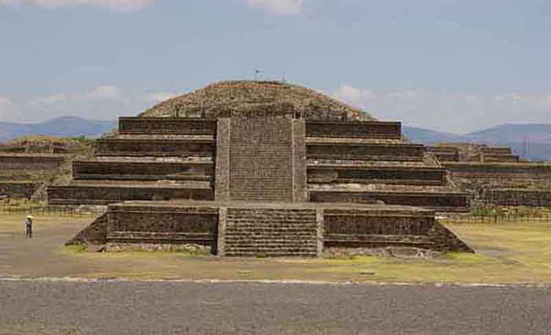
Another major program of excavation and restoration was carried out 1980-82 at the Pyramid of the Feathered Serpent and the Street of the Dead Complex. Most recently, a series of excavations at the Pyramid of the Moon have greatly expanded evidence of cultural practices.

Collapse

It was previously believed that sometime during the 7th or 8th centuries, the city was sacked and burned by invaders, possibly the Toltecs. More recent evidence, however, seems to indicate that the burning was limited to the structures and dwellings associated primarily with the elite class. Some see this as evidence that the burning was from an internal uprising and that the invasion theory is flawed due to the fact that early archaeological work on the city was focused exclusively on the palaces and temples, places used by the elites, and because all of these sites showed burning, archaeologists concluded that the whole city was burned. Instead, it is now known that the destruction in the city was focused on major civic structures along the Avenue of the Dead.

Some statues seem to have been destroyed in a methodical way, their fragments dispersed. Evidence for population decline beginning around the 6th century lends some support to the internal unrest hypothesis. The decline of Teotihucán has been correlated with the droughts related to the Climate changes of 535-536 CE. This theory is supported by the archaeological remains that show a rise in the percentage of juvenile skeletons with evidence of malnutrition during the 6th century. This does not conflict with either of the above theories however since both increased warfare and internal unrest can also be effects of a general period of drought and famine.

Other nearby centers such as Cholula, Xochicalco, and Cacaxtla attempted to fill the powerful vacuum left by Teotihuacan's decline. They may have aligned themselves against Teotihuacan in an attempt to reduce its influence and power. The art and architecture at these sites shows an interest in emulating Teotihuacán forms, but also a more eclectic mix of motifs and iconography from other parts of Mesoamerica, particularly the Maya region.

Pyramid of the Moon Photo Gallery


Pyramids and Temples of Mesoamerica


ShareThis


PYRAMID INDEX


SACRED PLACES AND TEACHINGS INDEX


ANCIENT CIVILIZATIONS INDEX


ALPHABETICAL INDEX OF ALL FILES


CRYSTALINKS MAIN PAGE


PSYCHIC READING WITH ELLIE


2012 THE ALCHEMY OF TIME

Posted by genlan 0 comments

The Hanging Gardens of Babylon
In some stories, people say that the Hanging Gardens went hundreds of feet into the air, but through archaeological explorations people now think were probably weren't that big. The ancient city of Babylon, which was under King Nebuchadnezzar II, must have been a wonder to a travelers. In 450 B.C., a historian named Herodotus wrote, "In addition to it's size, Babylon surpasses any city in the known world." Herodotus said the outer walls were 80 feet thick, 320 feet high, and 56 miles in length. He said that it was wide enough for a four-horse chariot to turn. Fortresses and temples containing immense statues of solid gold were inside the inner walls.
Above the city was the famous tower of Babel, which was a temple to the God Marduk. It looked like it reached the heavens.
Archaeological examination has found that some of Herodotus's claims (the outer walls seem to be only 10 miles long, and not nearly as high) might not be true. But his story does tell us how cool the features of the city appeared to those who visited it.
Accounts indicate that King Nebuchadnezzar built the garden. He ruled the city for 43 years starting in 605 B.C. According to accounts, the Gardens were built by Nebuchadnezzer to cheer up his homesick wife. Where she came from, there was green grass and mountainous plains. She found the dry, flat ground of Mesopotamia depressing. The King wanted to recreate her homeland.
Babylon rarely got rain and for the gardens to survive, it would have to have been irrigated by using water from the Euphrates River. People would have probably had to lift water very far into the air at each level. A chain pump was probably used to help. A chain pump is two large wheels on top of each other. Buckets are hung on a chain that connects the wheels. The bucket goes into the water then comes up and goes into a new pool.The empty buckets go back into the water to be refilled. The water at the top is then emptied through into a channel gate that is like a artificial stream to water the gardens.
Construction of the garden wasn't only complicated by getting water to the top, but also by having to avoid having the water wreck the foundation once it was released. Stone was difficult to get in Mesopotamian. Most of the buildings in Babel used brick.

Posted by genlan 0 comments


The Grand Canyon


The Grand Canyon is located in the northwest part of Arizona.

The Grand Canyon was made by the cut of running water. The Colorado River flows through the canyon. Some people think the Colorado River was there to start with and that over the years it cut through the rock, and now it is still there.

If you look in the canyon, you can see many layers of rock.

Geologists believe these rocks are at least two billion years old, which is almost certainly true, but no one can be exact.

About 500 million years ago, tiny sea creatures called trilobites lived in the sea. When they died, minerals from the ocean replaced their cells in their bodies. Then a long time after, the bodies petrified, they were fossils. There are no fossils at the bottom of the canyon, but near the top, you can find trilobites, and sometimes even footprints or so of reptiles.

Hiking in the Grand Canyon is very different from any other hiking because of its dry climate. Rangers say you need at least three liters of water for going down the canyon per day (remember, this is per person). You need less water in the winter, but you have to watch for freezing cold, rain, sleet or snow. You shouldn't have bare skin and in the summer you should wear light clothes and a hat. You should hike in the coolest part of the day and rest in shade at mid-day.

The weather is, well, very odd. In the middle of the canyon it gets very hot and dry. On the North Rim it is like the mountains. On the South Rim, it's a mixture of hotness and mountain-like. And canyon walls are pretty dry.

Three bridges cross the river: The Navajo, (used for vehicles) and two suspension bridges. Until 1907, the only way to cross the river was by a ferry. Later on, E.D. Wolly made a trail from the North to South rim. In 1921, they built a swinging bridge.


Posted by genlan 0 comments


Stonehenge

Stonehenge. You may have heard of it, you may not have. Stonehenge in considered by many to be an important landmark in space and time. We will many thousands of years back in time to explore this great monument.
Anyone who visits Stonehenge will probably be confused, and with good reason! They will have come through the car parking tunnel and then across a path, and they may not notice that they have just crossed the line of a bank, a ditch, and a ring of white concrete markers. They will probably be either staring up at the soaring stones above them or at the jumble of rocks at their feet.
"Who built it and why?" they will ask. People have wondered about Stonehenge for hundreds of years. We wonder who built it. Stonemasons wonder how the stones were cut to their rectangular shape. Engineers wonder how the stones were dragged to the site and placed upright. Jewelry and tools have been found near Stonehenge. Archeologists wonder at these. They wonder who made these things and who they made them for.
Anthropologists, too, wonder. What were the people like? Were they farmers, or did they hunt? Were they friendly, or war like? Some people believe that the people who built Stonehenge, were, as they say, Stone age Einsteins!
Now, you may ask, why was it built? Well, we're not exactly sure, but many think that its main purpose was to be used as some kind of calender. It marked important astrological events. It may also have had a religious purpose.
In the 1950's, archaeologists began excavations at Stonehenge. These proved that Stonehenge was built in three main stages from 2800 to 1500 B.C. Over the many
years between then and now, many of the stones fell or were dragged away to be used as bridges or dams. Scholars have learned what Stonehenge really looked like because of the stones remaining. This is a photograph of Maryhill Stonehenge, a monument built by Sam Hill as a tribute to soldiers who fought and died in World War I. It is a life-size replica of the original Stonehenge.
A wall of earth, 320 feet in diameter, surrounded Stonehenge.
Inside of the wall, thirty blocks of sandstone each 13 1/2 feet or 4 meters above the ground and weighing about 28 tons average, stand. On top, stones were placed end to end, balancing in a perfect circle. Then came 60 blue stones, about 4 tons average. Inside of this, 2 horse shoe forms were built, one inside of the other. A stone, 76 feet tall, stands 80 yards, or 73 meters, to the east of Stonehenge. This was put up in the first stage of building.
Some people think that it took 30,000 hours as well as hundreds of years to complete Stonehenge.

Posted by genlan 0 comments


The Colossus of Rhodes

It is sometimes called "Modern Colossus," but more often called the Statue of Liberty. The Statue of Liberty is somewhat like Colossus. Both were built as a celebration of freedom.
Originally, Colossus stood over 2,000 years ago at the Islands of Rhodes. It is located off of the southwestern tip is Asia Minor, where the Agean Sea meets the Mediterranean Sea. The capitol city, Rhodes, was built in 408 B.C.
In 357 B.C the island which was conquered by Mausolus of Halicarnassus (one of the other seven wonders) fell to the Persians in 340 B.C. and was finally captured by Alexander the Great in 332 B.C.
The Statue of Liberty, which is the same size as Colossus, weighs 225 tons! Colossus weighed a little more. Inside the statue were several stone columns, which acted as the main supports.
In the 7th century (A.D.) the Arabs conquered Rhodes and broke up Colossus, and sold it as scrap metal. It took 900 camels to take away the statue. It was a sad ending for what was a majestic work of art.
When Alexander died at an early age people could not decide who would reign. Three people: Ptolemy, Seleucus, and Antigous divided the kingdom between themselves. Antigous sent his son Semetrious to capture and punish Rhodes. The war was very long and painful. The city was protected by a strong wall. The attackers were forced to use siege towers and try to climb over it. Diameters had a second tower built. The second tower stood 150 feet high and 70 feet square at the base. It carried water tanks that were used to fight fires. The tower was mounted on iron wheels, and could be rolled. When Demetrious attacked the city, defenders stopped the machine by flooding a ditch outside the wall and moving the heavy machine in the mud.
To celebrate their freedom, the Rhodians built a giant statue of their patriot God Helious. Colossus was a Latin word, meaning any statue that is larger than life size.
They spelled it "Colossos" but then changed it to "Colossus." Colossus was built in 304 B.C. and it took twelve years to build it. The statue was 110 feet high and stood on the pedestal. Colossus was posed in a traditional Greek manner: nude, wearing a spiky crown, with his eyes shaded from the bright sun with his right hand while holding a cloak over his left hand.
Colossus stood shining in the sun for 56 years. Sadly, an earthquake hit Rhodes, and the statue collapsed. Huge pieces lay in the harbor for a long time. An Egyptian king decided to pay for reconstruction, but the people of Rhodes refused. They had feared that somehow, they had offended Helious who had used the earthquake to tear it down. Out of all of the wonders, Colossus was the one that stood the least amount of time. It stood for only 56 years, but in brief time won fame throughout the entire civilized world.

Posted by genlan 0 comments

Ancient Mayan

Mayan Geography

The area of the Maya civilization extended throughout the northern Central American region, including the present-day nations of Guatemala, Belize, western Honduras and El Salvador, as well as the southern Mexican states of Chiapas, Tabasco, and the Yucatán Peninsula states of Quintana Roo, Campeche and Yucatán. They occupied the eastern third of Mesoamerica, primarily the Yucatan Peninsula. The topography of the area greatly varied from volcanic mountains, which comprised the highlands in the South, to a porous limestone shelf, known as the Lowlands, in the central and northern regions. The southern portion of the Lowlands were covered by a rain forest with an average height of about 150 feet. Both the Highlands and the Lowlands were important to the presence of trade within the Maya civilization.

Lowlands

The Lowlands primarily produced crops which were used for their own personal consumption, the principle cultigen being maize. They also grew squash, beans, chili peppers, amaranth, manioc, cacao, cotton for light cloth, and sisal for heavy cloth and rope. The lowlands are a limestone shelf bordered on the north and west by the Gulf of Mexico and on the east by the Caribbean Sea. The northern lowland climate is hot, and the rainy season, from May through October, often brings insufficient rainfall. Permanent rivers and lakes are virtually nonexistent and only cenotes (large sinkholes filled with rainwater), provide precious water.

The southern lowlands consist of rainforest and savannas where lakes and rivers are fed by the mighty Usumacinta River. The rainfall was as high as 160 inches per year in the Lowlands and the water that collected drained towards the Caribbean or the Gulf of Mexico in great river systems. These rivers, of which the Usumacinta and the Grijalva were of primary importance, were vital to the civilization as the form of transportation for both people and materials.

Scattered savannas and swamps, or bajos, appeared sporadically, interrupting the dense forests. The northern Lowlands were also comprised of forests but they were drier than their southern counterparts, mainly growing small thorny trees. February to May was the dry season characterized by air that was intensely hot and uncomfortable. At this time of year, the fields had recently been cut and had to be burned in accordance with their slash and burn form of agriculture. The skies filled with a smoky grit, making the air even more unbearable until the rains came in late May to clear the murky atmosphere.

Highlands

The highlands are a wide swathe of mountains and valleys of the Sierra Madre, bounded on the south by a narrow coastal plain and the Pacific Ocean. Although subject to tsunamis, volcanoes and earthquakes, the soil is fertile and the climate pleasantly cooler than the lowlands. The rainy season is between May and November, with peak rainfall in June and October. The volcanic Highlands, however, were the source of obsidian, jade, and other precious metals like cinnabar and hematite that the Mayans used to develop a lively trade. Although the lowlands were not the source of any of these commodities, they still played an important role as the origin of the transportation routes.

Many dangerous animals occupied this region of the peninsula including the jaguar, the caiman (a fierce crocodile), the bull shark, and many species of poisonous snakes. These animals had to be avoided as the Maya scavenged the forest for foods including deer turkey, peccaries, tapirs, rabbits, and large rodents such as the peca and the agouti. Many varieties of monkeys and quetzal also occupied the upper canopy. The climate of the Highlands greatly contrasted with that of the Lowlands as it was much cooler and drier.


Posted by genlan Wednesday, September 16, 2009 0 comments


Petra, Jordan

Petra is the treasure of ancient world, hidden behind an almost impenetrable barrier of rugged mountains, boasting incomparable scenes that make it the most majestic and imposing ancient site still-standing nowadays.. It has been said "perhaps there is nothing in the world that resembles it", actually, for sure, there is nothing in the world that resembles it. The rock-carved rose-red city of Petra is full of mysterious charm, it was "designed to strike wonder into all who entered it".

more pics


Posted by genlan 0 comments


The Great Wall of China was built to link existing fortifications into a united defense system and better keep invading Mongol tribes out of China. It is the largest man-made monument ever to have been built and it is disputed that it is the only one visible from space. Many thousands of people must have given their lives to build this colossal construction.

The Great Wall of China is a series of stone and earthen fortifications in China, built, rebuilt, and maintained between the 5th century BC and the 16th century to protect the northern borders of the Chinese Empire during the rule of successive dynasties. Several walls, referred to as the Great Wall of China, were built since the 5th century BC. The most famous is the wall built between 220 BC and 200 BC by the first Emperor of China, Qin Shi Huang; little of it remains; it was much farther north than the current wall, which was built during the Ming Dynasty.

The Great Wall of China

Posted by genlan Tuesday, September 15, 2009 0 comments


Welcome to the mysterious ruins of Machu Picchu, Peru. Prepare yourself as you are about to embark on a virtual tour exploring one of the most intriguing destinations on the planet. Don’t worry... you won’t need heavy hiking gear or an experienced guide to tour the spectacular views and scenery the magnificent complex has to offer.

A Brief Overview

7,000 feet above sea level and nestled on a small hilltop between the Andean Mountain Range, the majestic city soars above the Urabamba Valley below. The Incan built structure has been deemed the “Lost Cities”, unknown until its relatively recent discovery in 1911. Archaeologists estimate that approximately 1200 people could have lived in the area, though many theorize it was most likely a retreat for Incan rulers. Due to it’s isolation from the rest of Peru, living in the area full time would require traveling great distances just to reach the nearest village.

Separated into three areas - agricultural, urban, and religious - the structures are arranged so that the function of the buildings matches the form of their surroundings. The agricultural terracing and aqueducts take advantage of the natural slopes; the lower areas contain buildings occupied by farmers and teachers, and the most important religious areas are located at the crest of the hill, overlooking the lush Urubamba Valley thousands of feet below.

Hikers, tourists, and the early explorers describe similar emotions as they climb their way through the Inca Trail. Many call the experience magical. Glancing out from the Funerary Rock Hut on all the temples, fields, terraces, and baths seems to take you to another time. Blending in with the hillside itself, many say the area creates a seamless and elegant green paradise, making it a must for anyone who travels to Peru.


Machupijchu

prologue
    "After almost four hours by train, on one of the most impressive and spectacular stretches in the world, from high, cold early morning plains down to lush vegetation in the frequently suffocating late morning heat, one arrives at the foot of the mountain Machupijchu. Then the eight kilometer road of thirteen zigzag hairpins in an acrobatic bus takes us up the mountain, and one arrives at the hotel. From here, it is only a few steps and the city opens itself. ..."
Machu Picchu

"To visit Machupijchu, you must prepare the soul, sharpen the senses. Forget for some minutes, the small and transcendental problems of our lives, of modern... man..."

      Napoleon Polo
The RailRoad,the Urubamba Ruver  and the Road.


"But this Pope does not interest me; much less will I obey him, I being in the kingdom of my father and our religion being good and I and my subjects are happy. .."


Llamas


"However, despite my being a son of Huayna Capac I cannot discuss anything so wise and old. ..."

Group of the Sacred Group
"The Christ that you speak of died, the Sun and Moon
never die, besides how do you know your god created the world?"
(This quotation is from Inca Atahuallpa's answer
to Fray Wicente Valverde, taken from Spanish
documents of the Indians Archives in Seville.
M.37. I show with no comment!)


Hiram Binghan
Hiram Bingham

Main Temple

Machu Picchu


Additional pictures of Machu Picchu

Waynapijchu
The Young Peak
Waynapijchu - The Young Peak

Waynapijchu - The Young Peak


Additional pictures of Machu Picchu - 2

LLAMA


Additional pictures of Machu Picchu - 3

LLAMA


Additional pictures of Machu Picchu - 4

LLAMA

pic web

http://www.fotosearch.com/photos-images/wedding_3.html http://www.thenagain.info/webchron/glossary/absmonarch.html
http://www.culturecrossing.net/basics_business_student_details.php?Id=14&CID=163

About Me

My photo
this is my way of showing what my interest in this world. hope you enjoy reading while learning.............

Followers

Total Pageviews